RESURSE INTERACTIVE GRATUITE PENTRU UZ DIDACTIC
08.10.2009
Online Free Learning website full of fun
Our website is designed to help students of different grades, starts from Kindergarten, Elementary, Middle School and High School Math.
The goal of this website is to provide new education tools to teachers, parents and off course students who can benefit from it.
Mathebook.net has Online Tutorials as well as Downloadable pdf tutorials which one can save on computer and use later, even it can be used by teachers for home work purpose, as this pdf is editable and kids can e-mail the homework tutorials by e-mail back to Teachers. By using Downloadable Tutorials one can save the waste of paper and SAVE TREES, so we encourage you to be GREEN, and help mother nature to survive.
Online Tutorials has the score card which allows them to know how may answers were right or wrong. If the kid does not know the answer our intelligent tool will show the correct answer, it’s a learning curve !
Downloadable Tutorials are easy to use, but you will need Acrobat Reader to use this format ( which can be freely downloadable at www.acrobat.com ) One can save the work sheet, even if required take print out or just simply e-mail it to teachers and friends. In our downloadable section you will find several such pdf to download.
I am sure this website will serve and make life easy for kids, but we have not stopped here, we will continuously develop and further enhance the syllabus and will keep adding new features.
If you have a suggestion which can improve the user experience, share with us and we will work to incorporate on this website. That’s our Promise.
Sa fiti iubiti!
Profesorul
23.06.2009
City information directly on your mobile
23 June 2009
This month, a start-up company from ESA's Business Incubation Centre launched a new mobile phone service which provides, with the help of satellite and telecommunication technology, location-based information on shopping, entertainment, tourism, and public transportation.
http://www.esa.int/esaCP/SEM74KQORVF_index_0.html
ESA
Sa fiti iubiti!
Constantin NITU
20.06.2009
Mapillary
29.05.2009
IRIDIUM Networks
Integrate both gsm/gprs and IRIDIUM dual radio system in one device
Very low latency time,send data from anywhere in the world in few seconds by IRIDIUM
IRIDIUM system support 66 satellites, G200R can work in high density city ,jungles and marines
Compare to other signle satellite system, IRIDIUM system can receive signal in all directions
Very low GPS message air time price, the cost will be lower than gsm SMS
Operate at 1.6G radio band frequency,G200R can be installed and tracking aircrafts
Support live video and fuel level real time monitoring
Worldwide vehice tracking web service with GlobalTrack WebMap with GOOGLE EARTH
Accessories include Camera ,Fuel level Sensor,Temperature Sensor,Vibrations sensor,G-sensor,Small Printer
Introduction to IRIDIUM Networks
The Iridium System is a satellite-based, wireless communications network providing a robust suite of Voice and Data services to virtually any destination anywhere on earth.
With 66 satellites forming a cross-linked grid above the Earth, the Iridium system is the first low-earth orbiting system for telephone service. Only 780km (450 miles) high, these satellites work different from those at a much higher orbit (26,000km) in two major ways. First they're closes enough to receive the signals of a handheld device; and second, they act like cellular towers in the sky - where wireless signals can move overhead instead of through ground based cells.
Frequency Bands
Telephone & Messaging 1616-1625.5 MHz,L-band
Intersatellite Links 23.18-23.38 GHz, Ka-band
Ground Segment Links
Downlinks 19.4-19.6 GHz, Ka-band
Uplinks 29.1-29.3 GHz, Ka-band
28.05.2009
How to create websites that use Google Maps/Earth to map information in a back end database
I am happy to be named a friend! I hope you and your students find this work useful. Sometime later this year I will release code on how to create websites that use Google Maps/Earth to map information in a back end database. You can see an example at http://ctasgis02.psur.utk.edu/tokml.
Hopefully, I will complete an e-book on how to program for KML mapping engines, both desktop and web based.
Cheers,
Bruce Ralston
27.05.2009
AFF Mapper - programe freeware
a Windows based package that was specifically designed for creating KML based mapping files from TIGER shapes and tables available from the Census Bureau's American FactFinder web page. While it was designed for these files, it can be used to create KML files for other shapes (that are in decimal degrees with NAD83 or WGS 84) and external attribute files. The resulting KML files can be viewed in several free mapping packages such as Google Earth and ArcGIS Explorer. To download a copy of
the program and the user manual, go to
[1]http://tnatlas.geog.utk.edu/downloadfree.htm. This is freeware, copy till you drop. Source code will be released at a later date." See also related stories below.
Link:
1. http://tnatlas.geog.utk.edu/downloadfree.htm
Sa fiti iubiti!
26.05.2009
10 Thoughts for Someone Contemplating a Geospatial Career
All things change over time. This includes geographic information systems (GIS), computer aided design (CAD), global positioning systems (GPS), remote sensing, surveying and a wide array of geospatial technologies and applications. What I would have said to someone embarking on a spatially related career ten years ago would be different than what I would say today. Some things have changed dramatically, others in new ways and some minimally. Here is what I’d say today to someone contemplating a geo-career, in no particular order.
1) GNSS is an integration of GPS satellite systems. You can actually use a GNSS receiver today and get excellent results. If you thought one GPS was good, then 2 or 3 are going to really open your eyes. GNSS is going to revolutionise all we know about location based services. It will create a whole new class of professionals interested in position and navigation.
2) GIS is the de facto integrator of spatial information. Focus on it. Learn how all other technologies are spokes leading toward its integration. If you understand it as existing on a level equivalent to business systems then you will have the power to strategically drive new business applications and directions.
3) 3D is the future. It is not just about data though, it is also about visualisation. Start using the phrase ‘elegant solution.’ Pay attention to the concept of ‘Digital Cities.’
4) Sensing will increasing play a role that is supported through legislation. Data matters and numbers matter. Carbon credits become a currency, for example, and geotechnologies the stock exchange. I can’t say enough about understanding monitoring and it’s linkage to geospatial technologies. The current economic crisis will eventually lead to transparency and more of it.
5) Our concept of time is not well defined in spatial technologies. We can do scheduling well, but being able to understand ‘change over time’ is becoming more meaningful. It also relates closely to real-time versus static operating environments.
6) Remotely sensed imagery will become more widely used. More satellites equal more data. But other new satellites are now going to be providing information about CO2, NOx, global soil information and so on. Linking those satellite data to imagery will mean projects become larger, involve more people and take on the character of spatial data infrastructure (SDI).
7) I can’t help but think that we heading toward a major shift in energy use, production and utilisation. The way I see it, oil and gas together with wind, solar and biofuels etc. will require a balanced approach with feedback loops to operational building systems, social factors and other impacts. We’re about to enter a more holistically oriented and managed energy scenario. This goes back to integration - GIS.
8 ) Think communities. Better and more efficient housing located near better and more efficienct tranportation systems.
9) Learn to write. Develop communication skills. Many of our colleagues tell me, “I wish I could write.” It will help you to share and collaborate on all the integration going on.
10) Find a mentor. A person who would agree to work with you as your career develops and who you would invest a time commitment toward. It can be daunting when starting out and many people can help you to get up to speed quickly. If you want a mentor, then simply ask them. But know what you are asking and be prepared to listen.
25.05.2009
Animatie in chimie
http://chimie.scola.ac-paris.fr/flash/electrolys.htm
http://chimie.scola.ac-paris.fr/sitedechimie/nouveautes.htm
17.05.2009
Moda de-a lungul timpului

FASHION ERA
Fashion-era contains over 715 content rich, illustrated pages of Fashion History, Costume History, Clothing, Textile and Social History
16.05.2009
888 Flash Back Movies of Historical Events
http://www.flashones.com/events/070423_en.php
http://www.enotes.com/william-shakespeare/shakespeare-an-introduction
Web Sites in the Virtual Grammar Lab
http://www.spunkyenglish.com/Century/listSites.php?Details=false&ListActivities=false
Istoria altfel
 ,,Cucerirea normanda a Angliei este reprezentata prin imagini pe „tapiseria de la Bayeux“, realizata in secolul al XI-lea, la curtea normanda a lui Wilhelm Cuceritorul si atribuită reginei Mathilde (1031 - 1083). Aceasta este o bucata de panza lunga de aproximativ 70 m si lata de circa 0,50 m pe care sunt brodate cu fire de lana in opt culori 58 de scene, incluzand peste cinci mii de personaje care au participat la evenimentele din 1066. Din Tapiserie rezulta ca au fost doborate paduri intregi pentru construirea si armarea a sapte sute cinzeci de corabii care trebuiau sa transporte, dupa calculele strategilor vremii, intre 12.000 si 15.000 de oameni peste Canal. Flota a fost gata la inceputul lunii septembrie 1066, dar inca cinsprezece zile, vanturi contrare l-au retinut pe Wilhelm in Normandia''(ALTERMEDIA.INFO)
Cu HISTORIC TALE CONSTRUCTION KIT te distrezi imaginand povesti medievale !
15.05.2009
14.05.2009
13.05.2009
Bedford Gis Session
Resurse online pentru Limbi straine
http://www.learnalberta.ca/content/ilglt/Flash/index.html?launch=true
http://atschool.eduweb.co.uk/haberg/reallyusefulge/default.htm
http://www.bbc.co.uk/languages/german/dplus/index.shtml
http://web.wm.edu/modlang/gasmit/german/?svr=www
http://dspace.dial.pipex.com/town/square/fk26/xword.htm
http://gut.languageskills.co.uk/general/links.html
2) Limba franceza
http://www.prescot-school.knowsley.sch.uk/prescot-language/mfl-site/primarySchool/FrenchPrimary.htm
http://www.laits.utexas.edu/fi/
http://www.fusee.co.uk/
http://www.learnalberta.ca/content/flbla/index.html
Story Tools
http://cogdogroo.wikispaces.com/StoryTools
VCASMO
http://www.vcasmo.com/
12.05.2009
Meanders and Floodplains
Geography Animation - Erratics
Discover how Rocks are Formed
Virtual Rock Kit
GeoHive Global Statistics
GEO-Mysteries
A Virtual Geography Journey
Clicmap
Tech Topics
Location
Curriculumbits.com
Geography Image Bank
11.05.2009
09.05.2009
Reviste online pentru prescolari
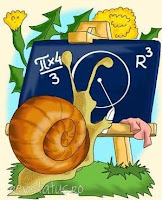
SUPER SITE PENTRU SUPER PITICI !
(Revista online Tus ( Ghidus ! )
RAZE
poezie de Mediana Stan
Calculează domnul Melc
Diametrul unui cerc,
Raza cea generatoare
E din păpădia soare.
În pistil ea se înfige,
Se roteşte într-o minge
Şi pe unde scânteiază
Lasă-n urmă altă rază.
Pi ori patru supra trei
Şi din raze sar scântei,
Înmulţit cu r la cub,
Iată sfera sus pe tub!
SAU
poezie de Mediana Stan,
Glob
Păpădie, păpădie,
Lampa ierbii, argintie.
De vrei noapte ca să fie,
Suflă-n glob de păpădie!
Alte pagini pentru prescolari
Izvoare istorice pentru Istoria Romanilor
Un site cu numeroase izvoare istorice romanesti si straine , util mai ales pentru
Istoria Romanilor .
08.05.2009
07.05.2009
Wildlife Filmmaker
Kerpoof Studio
http://www.kerpoof.com/
About Kerpoof:
Kerpoof is a website where your children can engage in creative play, interact with their friends in a safe environment and have fun. Kerpoof is owned and operated by the Walt Disney Company and has won major awards including Parent's Choice Foundation's Gold Award and The Children's Technology Review Editor's Choice Award. Kerpoof currently has many dynamic activities where children of all ages can express themselves to:
Make a Picture
Make a Movie
Make a Drawing
Make a Card
Make a Story
06.05.2009
Despre colaborare si creativitate
http://www.digitalgeography.co.uk/
Nenumarate sunt caile ..........profesorului de a preda geografia !
04.05.2009
Drawing on Google Maps

 http://googlemapsmania.blogspot.com/
Scribble Maps is a fun new map created using the Google Maps API for Flash. The map allows you to draw on Google Maps and is a quick and easy way to rapidly make and share your own maps.
http://www.scribblemaps.com/#id=WsSk6XSSE7
03.05.2009
Tikatok
Tikatok is a free online community enabling children to write, illustrate, share, and publish their own picture books. Provides the ability for collaboration between members, including one child illustrating and the other writing. Includes a separate teacher registration process and Teacher Dashboard for management of class projects.
MindMapping
http://www.bubbl.us
http://www.mindomo.com/
http://www.mindjet.com/us/
http://www.gliffy.com/
http://freemindshare.com/
http://www.mind42.com/
http://www.mindmeister.com/
http://en.wikipedia.org/wiki/FreeMind
http://vue.tufts.edu/
02.05.2009
Colectie de imagini din fosta URSS
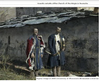
This digital collection presents over 700 images of Russia and the Caucasus region, particularly of rural areas in Georgia and Dagestan. The photographs, taken by William O. Field in the late 1920s and early 1930s, are housed at the American Geographical Society Library. The photographic collection is supplemented by Field's diaries and travel notes, and a selection of maps of the Caucasus region.
Iconografie crestina


Doua site -uri grecesti de o exceptionala calitate grafica si redactionala :
Muntele Athos
Muntele Sfant
Imagini si clipart - uri pentru uz didactic


Image After
Image*After is a large online free photo collection. You can download and use any image or texture from our site and use it in your own work, either personal or commercial.
Open Photo
Free Foto
Clipart ETC
#1FreeClipArt
Discovery Education
MAPS ETC
 Imperiul colonial britanic in 1910
Welcome to ETC's collection of historic maps.
Here you will find over 5,000 maps representing many different time periods.
01.05.2009
Caricatura , oglinda satirica a epocii
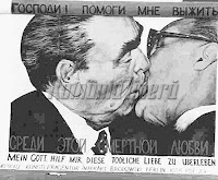
Un barbat moare si ajunge in iad. Aici descopera ca poate alege unde sa mearga, in iadul capitalist sau in iadul comunist . Cum era de asteptat, vrea sa le compare inainte sa aleaga, asa ca porneste spre iadul capitalist. La intrare sta diavolul, care aduce putin cu Ronald Reagan. "Cum este inauntru?", intreaba vizitatorul. "Pai – raspunde diavolul –, in iadul capitalist te jupuim de viu, apoi te prajim in ulei, dupa care te taiem in bucatele mici". "Dar e ingrozitor", bolboroseste barbatul, "mai bine merg in iadul comunist". Aici, descopera o imensa coada la intrare si, dupa o buna perioada de timp, ii vine si lui randul, fiind intampinat de un diavol batranel, care seamana nitel cu Karl Marx. "Inca sunt in lumea libera, Karl, spune barbatul, si inainte sa intru la voi, as vrea sa stiu cum este." "In iadul comunist – raspunde Marx nervos – te jupuim de viu, apoi te prajim in ulei, dupa care te taiem in bucatele mici." "Dar... este exact ca in iadul capitalist", protesteaza vizitatorul. "De ce asteapta atatia oameni la intrare?"'' Pai , ofteaza Marx , cateodata ramanem fara ulei , cateodata fara cutite, cateodata fara apa fiarta ''.
Sursa : Romania Libera30.04.2009
27.04.2009
Revista online Pagini Scolare
Relaxati-va cu .....hieroglife !

Egyptian Name Translator
A very interesting tool that takes the letters that you type in using the keypade (up to 11 letter) and converts them to heiroglphics.
Brown University Library - Digital Collections
 Napoleonic Satires
http://dl.lib.brown.edu/napoleon/cast.html
A collection of Napoleonic satirical prints produced between 1792 and 1829, from Germany, Britain, France, Holland, and Russia, by such noted artists as James Gillray and George Cruikshank.
http://dl.lib.brown.edu/collections.php
Colectie de texte sacre
2) All 78 texts across all faiths in chronological order. Each with zoomable high-res image, in-depth description, cross-links and more.
1200 de ani de sculptura italiana

An online database of sculptures from Italy. The images can all be zoomed.
You might ask students to scan the scuptures and then select and download specific images to include as illustrations for creative writings !
De ce nu ? ! Timp sa fie , mai exact ore suficiente pentru aplicatii si mai putina teorie in programele scolare !
25.04.2009
24.04.2009
Earth Album

Earth Album - is a simpler, slicker Flickr mash-up that allows you to explore some of the most stunning photos in the world courtesy of Google maps and Flickr. To begin your journey, just click somewhere on the map, e.g. "India". Note-- since the top Flickr images are used, the images change every few weeks; bookmark this site and check back for a different experience in a month!
23.04.2009
ARSights
Based on the Plug-in of GE for internet browsers, it allows users to download models from ARSights Placemarks (Network Link) and to experience them by using Augmented Reality Technology. All you need to make ARSights work is an Internet Connection, a PC, a WebCam, Google Earth Plugin and ARSights.
22.04.2009
Visualizing Topography
World Digital Library
Proiectul World Digital Library (WDL), care aduce la un loc unele dintre cele mai valoroase opere ale lumii, a fost lansat la Centrul UNESCO din Paris. Platforma online are structura unei ferestre digitale prin intermediul căreia internauţii pot accesa zeci de mii de texte rare din ţări precum Arabia Saudită, Africa de Sud şi Suedia. Biblioteca digitală este poziţionată ca un instrument educaţional singular în lume, materialele fiind accesate gratuit şi traduse în şapte limbi.
EuroparlTV
 Numeroase secvente video de actualitate care pot constitui un punct de plecare in construirea unor studii de caz pentru ora de cultura civica .
http://europarltv.europa.eu/LandingPage.aspx
21.04.2009
OzCoasts
GigaPan

Acest site contine numeroase imagini care pot fi exploatate in scop didactic pentru ilustrarea unor procese sau fenomene .
Alt avantaj pentru ora de geografie este legat de posibiltatea utilizarii concomitente a aplicatiilor Google Maps si Google Earth.
http://gigapan.org/index.php
19.04.2009
Pin in the map ( aplicatie )
View pin in Google Earth with this link:
http://pininthemap.com/ppaceffbc63209f390d/earth
http://pininthemap.com/
17.04.2009
16.04.2009
Marvel Super Hero

Daca oamenii politici romani va dezamagesc necontenit ,
,, configurati-va '' propriul erou care cel putin virtual
poate invinge criza !
http://www.marvel.com/create_your_own_superhero


